- 18,000-13,000 BCE: Laurentide Ice Sheet covers all of New England *
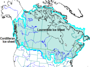
18,000-13,000 BCE: Laurentide Ice Sheet
- 12,000 BCE: Arctic tundra covers central New England. Evidence of first human presence in New England; start of mass extinction of Pleistocene Megafauna *
- 9000 BCE: Dramatic warming ushers in forests dominated by pines, oaks and birches *
- 1000 BCE: Forests of present composition dominate central New England *
- 1497: John Cabot may have spotted Mount Agamenticus. This would make Mount A the first land of North America to have been spotted by western explorers.
- 1602: Mount A is visited by westerners: Captain Bartholomew Gosnold, English navigator
- 1605: First distinct reference is made of the area (Mount A region) by the French
- 1614: Captain John Smith publishes map of New England and represents this area as “Snadoun Hill.”
- 1620: Westerners began to colonize this area, which had been occupied by the Abenaki Indians
- 1631-1634: The first gristmills were established in the Mount A area.
- 1654: The first recorded cutting of “Mast Pine,” “King Pine” or White Pine for the British Navy * (not specific to Mount A).
- 1752: The Outer Commons as this region was called, was shared for grazing and was technically “owned” by the King of England. In 1752 the land was divided between all white freeborn males of voting age.
- 1700-1800s: Only a few families began to inhabit the area. They relied on berries, basket making, lumber, and bark collection for both sustenance and for trade.
- 1840: The sheep industry and rural population levels peak in central New England; farm abandonment and a mass migration to the west begin.
- 1800s-1900s: Charcoaling is one of the largest industries on Mount A. Chestnut Oak, known for the tremendous heat that this hardwood can produce and for its minimal value as lumber, was cut extensively in order to fuel both the local blacksmiths and the burgeoning industries in town.
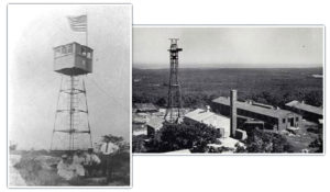
- 1918: The original fire tower was built on the Summit of Mount A. It stood near the current summit parking lot.
- 1938: The fire tower was taken down.
1941: Summit Radar Tower is Constructed
- 1941: Summit Radar Tower is constructed: first of its kind in the US. The summit was cleared of trees in order to build army barracks to house the 25 men whom manned the tower.
- 1944: winter: A fire on the summit burned down all of the army buildings.
- 1950s: Early in the 50s, the second fire tower on Mount Agamenticus was installed.
- 1960: Planning and construction begin for the “Big A” Ski Area. One rope tow and two ski lifts service this publicly owned ski area. An artificial pond is created on the western side of the mountain (Kilgore Swamp) to supply water for the snow making facilities.
- 1964: The Big A Ski Area opens.
- 1974: The Big A Ski Area closes.
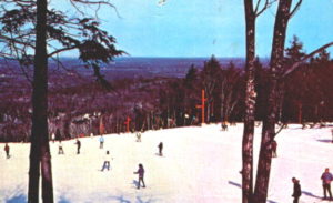
1970: Big A Ski Area
- 1970: The first of many antennae was installed on the summit.
- 1970s: The “Save Agamenticus” committee was formed in response to a development proposal (3000 residential units). The committee was hoping to establish the area as a wilderness area or a wildlife preserve. The Mount Agamenticus Steering Committee was also established in order to develop planning guidelines. Private land was being purchased in the name of conservation with an emphasis on preserving the natural resources, water quality and maintaining the recreational resources of the area.
- 1977 and 1978: Mount A was the first release site for the Wild Turkey in Maine after it had been extirpated from the state. 25 individuals were successfully released each winter. There are now approximately 40,000 birds statewide.
- 1981: Due to its unsafe condition, the original fire tower was torn down and replaced, via helicopter, with a new lookout tower.
- Present: Many public, quasi-public and non-profit groups continue to purchase property in the area surrounding Mount Agamenticus. Most of the public and quasi-public land is managed cooperatively in order to promote a healthy ecosystem and to provide for year-round recreation resources. The fire tower is owned by the State of Maine and operated by the Town of York. Since 1991, the tower was responsible for spotting approximately 800 fires.
* From Tom Wessels Reading the Forested Landscape: A Natural History of New England, appendix a: A Central New England Chronology
Last modified: January 31, 2019