Directions
Lat/Long Coordinates: N43.22303, W70.69262
Directions to Mount Agamenticus from the North:
Take I-95 South to Wells (exit 19).
Turn left from exit onto route 109. Go 1 ½ to 2 miles to route 1.
Turn right (south) onto route 1.
Follow route 1 into Ogunquit and through “downtown.”
At the flashing yellow light hanging over the road, turn right onto Agamenticus Road (turns into Clay Hill Road). Continue about 4 miles (crossing over the Maine Turnpike) to the T-intersection at the end.
Turn right onto Mountain Road and follow it for about 1 mile.
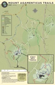
There is a gravel parking lot on the right and a paved road leading to the summit of Mount Agamenticus. Red fence posts at the entrance say “Mount A Summit.” If the road turns to gravel, you’ve gone a hundred meters too far. Turn right and drive up to the summit or park in the gravel lot to hike up. Trail maps are available at the trailheads and the kiosk located at the summit parking lot.
Directions to Mount A from the South (using Route 1):
Take I-95 North into Maine. Take Exit 7, York (the last exit before the tollbooth for the Maine Turnpike).
Follow signs to Route 1 North (keeping right after the exit ramp). Turn left onto Route 1 North.
Approximately 3.5 miles after turning onto Route 1, turn left on Mountain Road (Across from Flo’s Hotdog Stand).
Follow Mountain Road for approximately 4 miles to a stop sign after crossing the interstate. Turn right and continue on Mountain Road for approximately two and a half miles from the interstate overpass. There is a gravel parking lot on the right and a paved road leading to the summit of Mount Agamenticus. Red fence posts at the entrance say “Mount A Summit.” If the road turns to gravel, you’ve gone a hundred meters too far. Turn right and drive up to the summit or park in the gravel lot to hike up. Trail maps are available at the trailheads.
Directions to Mount A from the South (using back roads):
Take I-95 North into Maine. Take Exit 7, York (the last exit before the tollbooth for the Maine Turnpike).
At the end of the exit ramp, turn left.
Go a few hundred meters to Chase’s Pond Road (between the exit ramp and the parking lot).
Turn right on Chase’s Pond Road. Continue about 7 miles to the mountain (road name changes to Mountain Road after about 4 and a half miles).
There is a gravel parking lot on the right and a paved road leading to the summit of Mount Agamenticus. Red fence posts at the entrance say “Mount A Summit.” If the road turns to gravel, you’ve gone a hundred meters too far. Turn right and drive up to the summit or park in the gravel lot to hike up. Trail maps are available at the trailheads.