Our Work

Since 1999 conservation work at Mount Agamenticus has focused on protecting the natural resources of the area by managing recreational use, remediating trails and habitats, and educating the public.
Thanks to the collaborative conservation efforts of many partners, volunteers and donors, Mount A has become a wonderful place for the local community to enjoy the outdoors, experience its scenic beauty, and to appreciate its significance as one of “Maine’s Last Great Places.”
Land Acknowledgement
The Mount Agamenticus Conservation Region is located in the traditional territory of the Wabanaki Confederacy. We acknowledge the Pennacook Abenaki people of the Wabanaki Nations as the first inhabitants and original stewards of this land that we now call York, Maine. We recognize and honor the nations who comprise the Wabanaki Confederacy (Waponahki) — the Mi’kmaq, Maliseet, Passamaquoddy, Penobscot, and Abenaki.
Management Today
In April of 1975, in the early stages of this nation’s latest environmental movement, the “Save Agamenticus” committee was formed in response to a development proposal (3000 residential units). The committee was hoping to establish the area as a wilderness area or a wildlife preserve. The Mount Agamenticus Steering Committee was also established in order to develop planning guidelines. Private land was purchased with an emphasis on preserving the natural resources, water quality and maintaining the recreational resources of the area.
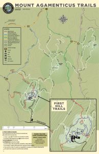
Today Mount Agamenticus provides a rare opportunity to both outdoor enthusiasts and wildlife in the midst of rapidly growing York County. An attraction to tourists and locals alike, the mountain draws crowds of day-trippers to enjoy breathtaking panoramic views from the Atlantic Ocean to New Hampshire’s White Mountains and to explore its 40+ miles of trails. According to a recent visitor’s survey, repeat visitors are increasing in number and travel to the area from neighboring towns in Maine and New Hampshire several times monthly to enjoy activities such as hawk and bird watching, hiking, biking, snow-shoeing, cross country skiing, hunting, and horseback riding.
PDF files below will open in a new tab. Larger file sizes are noted.
Yearly Conservation Program Updates
Other Documents


