Written by Dr. Wilfred. B. Bryan. *
Mount Agamenticus is located within the exposed upper part of the “plumbing system” that supplied lava to a very large volcano that was active about 220 million years ago. The complete structure is nearly circular, with a diameter of about 7 miles, the center being just south of Agamenticus Village in Bracey Swamp. The sharp summit is not “the volcano” as some may speculate; it is, along with Second and Third hills, an erosion-resistant part of one of the circular dikes that once supplied lava to the eruptions. The original volcano may have reached an elevation of as much as 20,000 feet, similar to Mount Kilimanjaro in eastern Africa.
When this volcano was active, North America was still attached to Africa, and according to current interpretations a strip of land along the Maine coast and extending out to the edge of the continental shelf is a piece of Africa that remained “stuck” to North America when the continents began to move apart, forming the Atlantic Ocean. Mount Agamenticus is located within a long line of volcanic structures which extends more than 1000 miles seaward as a line of conical submarine volcanoes; landward, the line continues northwesterly through southern Maine and New Hampshire into Quebec. This volcanic alignment resembles that of the Hawaiian Islands and the long chain of seamounts that extends northwest from the islands toward Siberia. This is one of our best examples of a “hotspot trace.” In this interpretation, each island and seamount is like a “puff of smoke” emitted from a fixed rising plume of hot lava as the seafloor drifts slowly over the source. In the Hawaiian example, this concept is generally supported by the increasing age of the islands and seamounts going northwest from the presently active southernmost island.
Unfortunately, this model is not well supported by age dating of the volcanic structures in new England and Canada. If the “puff of smoke” concept were true here, the oldest “puff” should be near Montreal, the farthest point from the source, and the youngest should be at the seamount closest to the source. The seamounts do get older as they approach New England, but the oldest on-land volcanic centers are in central and northern New Hampshire, while the youngest are found both near Montreal and in coastal Maine (Tatnic Hills, Alfred ring dike complex, and Cape Neddick gabbro, all dated at about 120 million years). So Agamenticus is an older volcanic event apparently associated with the initial rifting and is only fortuitously located on the alleged hotspot trace. Also, the Canadian volcanic centers are aligned along an east-west line that seems to be related to a separate volcanic episode related to rifting along the St. Lawrence valley.
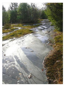 Agamenticus, like the rest of New England, has been covered by as many as four major advances of continental ice sheets during the past several million years, but we see direct evidence of only the last advance in most of New England. About 18,000 to 20,000 years ago the ice had advanced as far as the continental shelf and may have covered Agamenticus under as much as 5000 feet of ice. Rock material frozen into the base of the ice acted like a huge sheet of sandpaper as the ice ground its way seaward from northwest to southeast. The effects of the scratching and polishing by the glacier are beautifully exposed on the lower slopes of some of the old ski trails, where soil has been eroded away.
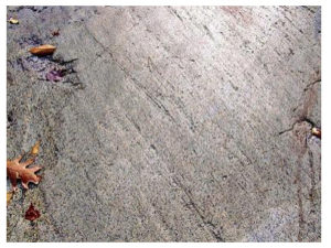
* Dr. Wilfred B. Bryan is a retired Senior Scientist at the Woods Hole Oceanographic Institution, where he has done research on deep sea spreading centers and volcanology, seamounts, and oceanic islands.
Last modified: February 8, 2019