Parking and Restroom Project Update

UPDATE June 30, 2023: At this time, the Parking portion of our project is complete! Restroom construction will continue through July 2023. Thank you for your patience and support!

The Mount Agamenticus Parking and Public Restroom project, approved by voters in 2020 has begun as of September 2022 and will continue through June 2023. Road, parking, and trail closures are expected until further notice.

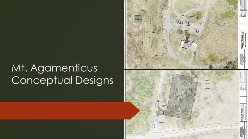
The parking project includes the construction and expansion of both the summit and base parking lots in addition to a satellite lot along the summit access road. This will greatly improve public safety, congestion, and the flow of traffic. The public restroom upgrades include the construction of composting toilet facilities located at both the summit and base. These will replace the portable facilities that currently exist at these locations. Composting toilets were selected due to the limited water supply and flow impacting water capacity for a flush system at the summit and comes with added environmental benefits.

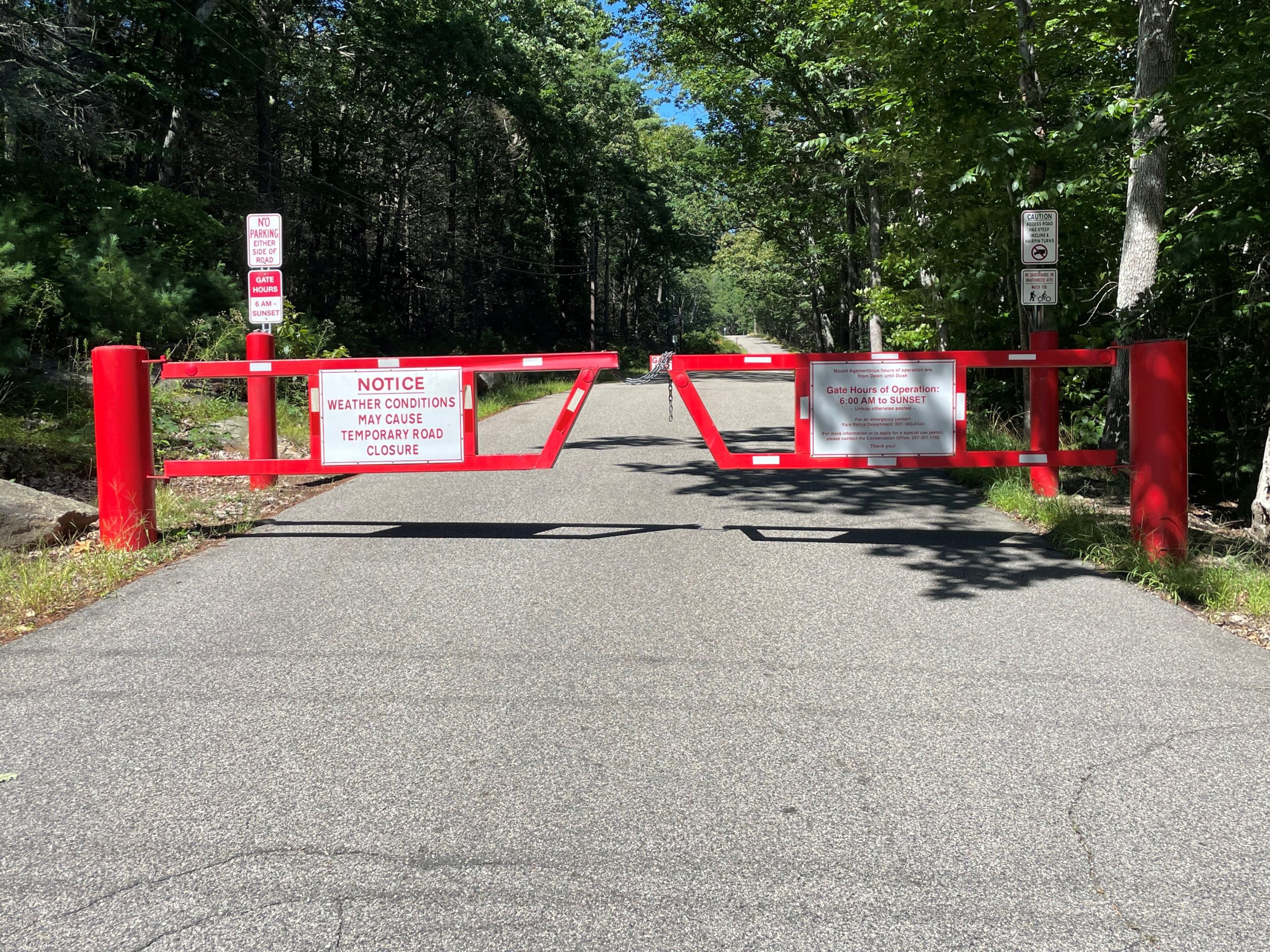
During construction visitors can expect the Mount Agamenticus Road (road to summit) to be closed to all public access, including pedestrian and bicycle traffic.

  • Limited parking is available along Mountain Road.
  • Park in designated areas only.
  • Visitors will be temporarily redirected around construction to a trailhead nearby.

If the gate at the bottom of the access road is open, the ROAD REMAINS CLOSED.

The summit is an active construction site at all times.  

Visitors are strongly encouraged to seek alternative places to recreate at this time.

We are fortunate to have so many trails and conserved land in this region. Visit Maine Trail Finder for other trails to explore OR visit our partners at Great Works Regional Land Trust and York Land Trust.

More information about the project can be found here.

Please contact us with any questions!

Three Simple Tips for Mud Season

photo of boot imprints in mud

It’s the season to get your boots dirty! How can you recreate responsibly and help protect our trails during mud season?

 1. Wait until trail surface has firmed up. Do more by doing less! Activities like running, biking, and ATV use have a higher impact during mud season. Tires sink into the mud, leaving deep ruts and causing water to pool up. Running impacts the trail more than walking because of the force of your body’s weight coming down on the trail. When the ground is wet, go for lower impact activities.

2. Walk single file and in the middle of the trail. Bring footwear to match trail conditions. Stick to rocks whenever possible and go through, not around around, muddy sections to help preserve the natural environment of the trail. Going around muddy areas widens the trail, causes erosion, and negatively impacts roots and vegetation. So, have fun and get muddy!

3. Get involved! Become a Trail Adopter or attend a Community Work Day. The best and most needed time to get out and start caring for trails is in the spring. Clean up downed branches and trees and clear out drainages so that water moves more quickly and effectively off trail. Learn about volunteer opportunities at Mount A.

Our actions matter! Learn more about Leave no Trace (external link opens in a new tab). 

A Beginner’s Guide to Hiking Mount A This Winter

This article was written by former Trails, Grounds and Facilities Supervisor, Darin Radatz, and first appeared in the Winter 2018 Summit View. For past editions of the Summit View, click here

The snow, ice and cold of winter have arrived but that does not mean the hiking season has to be over. With planning and proper preparation, a winter hike can be a safe and enjoyable experience. Please keep the following in mind when planning an outing:

Check the Weather – Look specifically for precipitation, wind speed and daylight hours.

Start Small and Start Early – Be reasonable about the distance and difficulty of the trail. While it may be easy to hike 10 miles in summertime conditions, you may run into ice or deep snow on the same trail in the winter.

Safety Gear – Put these in your backpack:

  • 1st Aid Kit
  • Trail Map
  • Compass
  • Multi-Tool
  • Hand Warmers
  • Full Water Bottle
  • Granola Bars
  • Headlamp

Crampons or Snowshoes – For icy trails such as Sweet-fern and Vulture’s View, use crampons, which are a traction device that is attached to footwear to improve mobility. For snow over 4 inches, use snowshoes which distribute weight so you don’t sink in the snow.

Buddy System – Hike with a friend and make sure to tell another of your hiking plans. Remember to also let them know when you have returned from the trail safely.

Wintertime Navigation – Use Trail Blazes, which are the rectangular paint markers found on the trees on the trail route. The trail map will indicate the blaze color of the path you choose. Distance between blazes varies, however if you have gone as much as a quarter mile without seeing a blaze, STOP. Retrace your steps back to find the last blaze. After a new snow, or on more remote trails within the management area you may find that trail blazes are the only way to be certain you are on the correct path.

Hot Tea or Cocoa – Having an insulated thermos of a hot drink will warm you up and provide a nice break!

Don’t Forget – The Mount Agamenticus park and trails are open year round, dawn to dusk. Summit access road gate hours from October through March are 7am-sunset. Weather conditions may cause temporary road closure!

Happy trails and be safe!


We Are Planning for the Future!

There is no doubt that Mount Agamenticus has been discovered! Over an estimated 50,000 people visit the area each year to enjoy its natural beauty, scenic vistas, and unique network of over 40 miles of trail. It has become apparent through visitor feedback, direct observation and vehicle traffic studies that use continues to increase and the area needs attention to address this growth.

Parking improvement and public restroom upgrades have been proposed for both the summit and base of Mount Agamenticus.  Visit the Planning for the Future page for more information about this project, including planning documents, photos, maps and video showcasing the work to date.