Trails & Activities
 The Mount Agamenticus Conservation Region consists of more than 10,000 acres and is located within an additional 30,000 acre expanse of conservation land in southern Maine. This land is comprised of a rich and unique coastal forest that supports the highest diversity of animal and plant species in all of Maine. The mountain and the surrounding area provide residents with an ideal location for hiking, biking and sightseeing. While most of Southern Maine is heavily developed, this stretch of conservation land is a natural treasure that will be preserved for the enjoyment of generations to come.
This land is critical habitat to many of Maine’s rare plants and animals. Mount Agamenticus is unlike any place else on earth and its conservation depends on you. Please tread lightly.
Mount A’s trails are for hikers, bikers, and other seasonal activities such as snowshoeing. Select trails are open to equestrians and ATV riders. As you travel the trails, we hope you will discover why this place is special.
To ensure long-term trail quality and to protect against erosion, trails are designated for specific uses. Trail signs, color blazes and the trail map tell which uses are permitted on each trail.
The trails at Mount Agamenticus are planned and managed. Please stay on marked trails. Do not cut switchbacks or create new trails. Stunt building or any other trail manipulation is prohibited. Possession of handsaws, chainsaws, loppers, shovels, rakes, or any other trail clearing or building tool or material is prohibited.
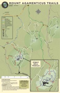
Click here for our trail map.
When using the trails, read the TRAIL SIGNS just like STREET SIGNS to know the name of the trail and the authorized uses.
➤ Trail Descriptions for Summit and Base Trails
Educational Walks & Programming:
➤ Mount A Tree ID Loop (4 MB clickable PDF opens in new tab) | Map Image Only
➤ Mount A StoryWalk® (on the trail: Little Brother Moose by James Kasperson with illustrations by Karlyn Holman)
➤ Summit Learning Lodge
Page last updated December 30, 2024.